

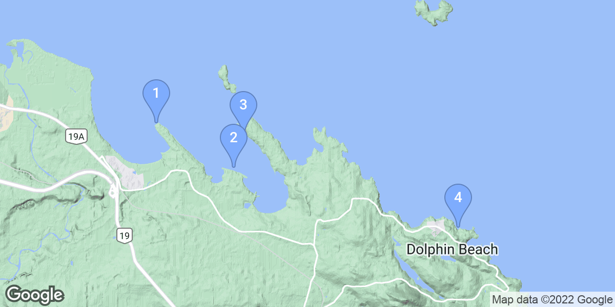
Top Snorkeling and Scuba Diving in Nanoose Bay
Ready to check out the best sites in Nanoose Bay for scuba diving, snorkeling, shore diving, free diving or other ocean activities? Zentacle has 4 dive sites, snorkel spots, beaches, and more. Discover hand-curated maps, along with reviews and photos from nature lovers like you.
No matter what you're looking for, you can find a diverse range of the best ocean activities in Nanoose Bay to suit your needs.


#1 - Madrona Point
Canada, British Columbia, Vancouver Island
There are two walls here. One as you enter the water, and a much deeper wall whose top starts at about 40 feet and descends below 100 feet. For first time divers, the left most path to the water gives a good starting point as it's easy to enter and the depth is about 20' or so. Watch your footing as there is lots of seaweed on the rocks when the tide is out. There is a channel cut into the rock and can make entering easier then jumping from the rock edge. The second wall most western end can be found at roughly 360 degrees magnetic north. Follow the path from the vehicles straight out to the water (roughly north)and enter the water in a shallow channel. You will have a surface swim of about 500' or so, head out at a North East heading (you can see a snow covered peak in the distance - aim for that)and then descend.
The two walls have lots of life on them, there are wolf eels on the outer wall and octopus on both. Crab, lingcod, dogfish etc... can also be seen here and at times the seals will visit.
In the spring,summer the visibility can be tough at times (10' or less)but usually at depth it improves. Winter is the best but we have had awsome vis (80' plus)in June. It just depends on the plankton bloom.
Follow the Island Hwy north towards Parksville, at Nanoose Bay you will come across Northwest Bay Road at the set of traffic lights. Make a right on to it. Follow Northwest Bay Rd for a few kilometers, and make a right onto Arbutus Drive, then a left onto Madrona Drive and follow it to the end. About a kilometre. The end of Madrona Drive is the parking lot. There is only room for about four cars here. Once your parked, there is a bit of a hike down to the shore. Follow the path and once through the clearing, turn left to go to the shallow wall or go straight (follow the "V" in the rock) to enter for the far wall.
Madrona Point is also known as Madrona Wall.
#2 - Wall Beach
Canada, British Columbia, Vancouver Island
Varied wildlife, Octopi, Wolf Eels, Ling Cod, Anemone.
Park at the end of the street and follow the short path 20 to 30 ft to shore.
#3 - Beachcomber South Wall
Canada, British Columbia, Vancouver Island
The dive: Continue down, the slope steepens until around 85 ft then really steepens, by app 115 ft becomes close to vertical. There is a large fishing net draped over the edges. Some cloud sponges below 160 ft. Imagine a 15 story wall 4 minutes swim from the beach.
Park off road near obvious trail near the Beachcomber Regional Park sign. Walk down trail to beach (nice gravel at high tide, slippery larger rocks at low tide). Enter and swim directly magnetic south, perhaps angling a little left over the clam beds till you find the rocks.
#4 - Dolphin Beach
Canada, British Columbia, Vancouver Island
Follow the Island Highway from Nanaimo. Then turn off at Nanoose Bay onto Northwest Bay Road then follow it until you can make a right onto Steward Road. Follow it until it turns into Davenham Road then into Dolphin Drive and then keep an eye out for Tyee Crescent. Then just park beside the mail boxes, at the corner of Tyee Crescent and Dolphin Drive.
Dolphin Beach is also known as Tyee Crescent Beach.